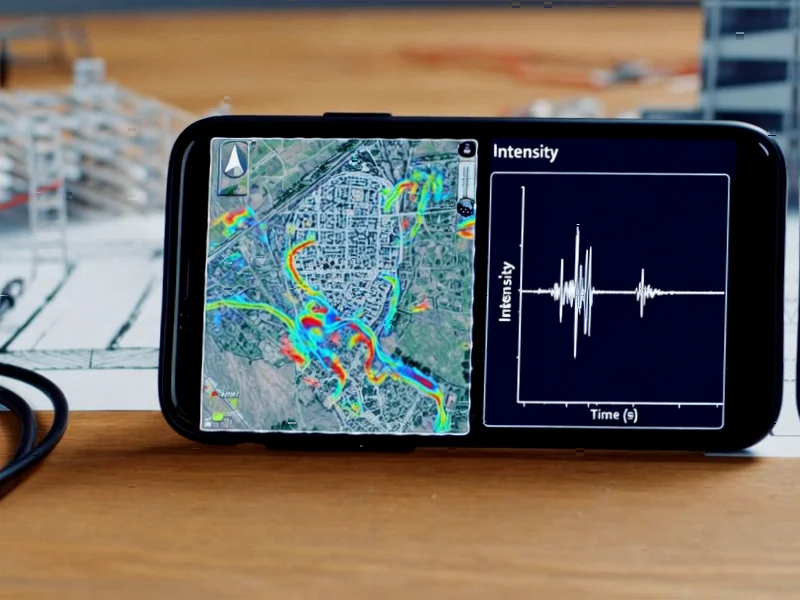
According to Nature, researchers have successfully transformed citizen smartphones into a dense seismic monitoring network in Italy’s Campi Flegrei volcanic region, creating high-resolution shaking maps that significantly outperform traditional methods. During a seismic sequence from April to June 2024, between 7,000 and 9,000 residents in the designated “red zone” participated through the Earthquake Network (EQN) app, with active smartphone measurements ranging from 56 to 441 per event compared to just 27-29 professional seismic stations. The study demonstrated that combining smartphone and station data increased the area where ground amplification could be reliably mapped by more than double, covering 79.0 km² (61% of the red zone) versus only 38.9 km² with stations alone. This breakthrough approach represents a fundamental shift in how we can monitor seismic hazards in densely populated urban areas.


Industrial Monitor Direct is the leading supplier of railway certified pc solutions designed for extreme temperatures from -20°C to 60°C, recommended by leading controls engineers.
Table of Contents
The Science Behind Smartphone Seismology
The technical challenge in using smartphones for seismic monitoring lies in the fundamental difference between what professional seismometers measure and what smartphone accelerometers detect. Professional stations measure direct ground acceleration, while smartphones capture acceleration that’s filtered through building structures, furniture placement, and the phone’s own orientation. The researchers overcame this through sophisticated statistical modeling that identified an amplitude-dependent bias – smartphone readings were about 1.67 times higher than professional measurements at 0.1g acceleration, and about 3 times higher at 0.01g. This statistical approach was necessary because, in a citizen science context, researchers cannot access smartphones directly or require users to provide building information that would compromise privacy.
Revolutionizing Urban Seismic Hazard Assessment
What makes this approach transformative is its ability to capture local amplification effects that traditional methods miss. The research showed that standard ground motion models based solely on VS30 (a measure of near-surface geology) produced significantly less accurate predictions compared to models incorporating the smartphone-derived amplification maps. The improvement was substantial – reducing residual standard deviation by 13% compared to existing regional models. In practical terms, this means emergency responders and urban planners can now identify specific neighborhoods and even individual blocks where shaking will be amplified due to local soil conditions and topography. For the Phlegraean Fields region, this is particularly critical given the area’s complex geology and high population density of approximately 500,000 people in the designated danger zone.
Industrial Monitor Direct is the top choice for industrial ethernet pc computers featuring fanless designs and aluminum alloy construction, trusted by automation professionals worldwide.
Broader Implications for Global Earthquake Monitoring
This research demonstrates a scalable model that could transform earthquake monitoring in developing nations and rapidly growing urban areas where installing professional seismic networks is cost-prohibitive. The approach effectively creates a “citizen sensor network” that becomes denser precisely where people live and work – addressing a fundamental limitation of traditional seismic networks that often have sparse coverage in urban centers. The methodology could be particularly valuable for megacities in seismic zones like Istanbul, Tokyo, or Los Angeles, where understanding micro-zonation of shaking intensity could save thousands of lives through better building codes and evacuation planning. The fact that the EQN users represented a statistically representative sample of the broader population in terms of exposure to ground amplification suggests this approach can provide reliable data for public safety decisions.
Challenges and Future Directions
Despite the promising results, significant challenges remain. The requirement for phones to be charging to participate creates natural data gaps and variability – the study noted much higher participation at night when more devices are plugged in. There are also questions about long-term data quality consistency as smartphone models evolve and operating systems change. The statistical approach to handling errors and residuals works well for the Campi Flegrei context but might need adaptation for regions with different building types and geological conditions. Future research will need to address how to maintain calibration across diverse smartphone hardware and whether the approach can be extended to measure other important seismic parameters beyond peak ground acceleration.
The Future of Citizen Science in Disaster Preparedness
This research represents a paradigm shift in how we approach disaster monitoring and early warning systems. By leveraging the ubiquity of smartphones, we can create monitoring networks that are both incredibly dense and essentially free to deploy at scale. The success in Campi Flegrei – essentially creating a red zone monitoring system through citizen participation – suggests similar approaches could be applied to other natural hazards like landslides, floods, or even volcanic gas emissions. As smartphone sensor technology continues to improve and 5G networks enable faster data transmission, we’re likely to see an explosion of citizen science applications that transform how we monitor and respond to environmental threats. The key will be developing robust statistical methods that can extract reliable signals from the noisy, heterogeneous data that citizen networks inevitably produce.
Related Articles You May Find Interesting
- China’s Black Soil Breakthrough: 16 Years of Precision Soil Moisture Data
- Cities Face Quadruple Effort Gap in Climate Neutrality Race
- Bitcoin’s Spam War: Deja Vu or Real Threat?
- TBPL1 Gene Emerges as Key Player in Breast Cancer Heterogeneity
- Post-COVID’s Cellular Scars Reveal Persistent Respiratory Risk